On the eve of the celebration of Gratitude Day, on February 27, 2026, a charity fair was held at the Faculty of History, Economics and Law, bringing t Read more
Quotation gallery
Upon the education of the people of this country, the fate of this country depends.
Benjamin Disraeli
Faculty News
On February 27, 2026, in anticipation of the «celebration of Gratitude Day», the Faculty of History, Economics, and Law hosted a warm gathering and a Read more
On February 27, 2026, the Faculty of History, Economics and Law held a career guidance meeting with students of the «Foundation» program and future ap Read more
24 февраля 2026 года на базе Северо-Казахстанский высший медицинский колледж имени Жұмағали Тлеулина КГУ «УЗ акимата СКО» прошла областная олимпиада п Read more
On February 19, 2026, students of the Faculty of History, Economics, and Law actively participated in the large-scale action «Nashakorlykka Zhol Zhok! Read more
On February 19, 2026, the Faculty of History, Economics, and Law held an explanation of the draft new Constitution of the Republic of Kazakhstan. The Read more
As part of the activities of the Kozybayev Alumni Association, a meeting was held at the Faculty of History, Economics, and Law, which became a signif Read more
17 февраля 2026 года в учебно-лабораторном корпусе (аудитория 636) состоялась литературно-музыкальная композиция «Бір шаңырақ астында» / «Под одним Read more
На базе медицинском факультете НАО «Северо-Казахстанский университет имени М. Козыбаева» состоялась дискуссионная площадка «Современная конституционна Read more
Students of the Faculty of History, Economics and Law, 3rd year of the educational program 6B04108 «Business and Management» (US), Zhanna Aleksandrovn Read more
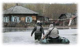
Modeling the development of a flood situation in the North Kazakhstan region with the construction of a full-scale model based on data from remote sensing of the Earth
Priority area: Information, telecommunication and space technologies, scientific research in the field of natural sciences
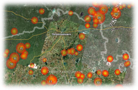
Project manager: Sartin S.A., candidate of physical and mathematical sciences.
Project executors: Ruder V.P., master, Shchukina V.N., master, Fomin I.A., master, Ponomarenko A.S., master.
Terms of execution: 2018-2020
Amount of financing: 94,200,000 tenge.
The goal of the project is to obtain high-resolution remote sensing data (via aerial photography) and process them using geographic information systems (GIS). Development and testing of a sensor for automatic detection of snow cover thickness.
Expected results: to develop a mathematical model for the forecast of spring flooding on the Yessil river, which will provide a forecast of the water rise level near settlements with an accuracy of 1-2 meters, will allow modeling the zones of probable flooding, track the dynamics of flooding processes in floodplain territories, and assess the flooded areas by means of an unmanned aircraft. The implementation of this project will allow you to obtain and constantly Refine a 3d model of the floodplain relief.
Project description: Currently, work is actively underway in the field of remote sensing of the earth using modern geodetic equipment, as well as unmanned aerial vehicles (UAVs). It is planned to create a full-scale model of the Yessil (Ishim) river floodplain, data on the depth of snow cover in the Yessil (Ishim) river basin, and bottom profiles obtained using a six-beam echo sounder to create a full-scale model of the Yessil (Ishim) river flood near localities and the degree of their flooding. Development of a model for the development of the flood situation between the cities of Sergeevka and Petropavlovsk. The model will be adjusted quickly to take into account newly received data on the state of snow cover in the Yessil river basin (Ishim).
Project objectives:
−obtaining high-precision geodetic data on the Esil river floodplain;
−obtaining data on the state of the Esil river bed;
−development and implementation of methods for remotely obtaining data on the state of snow cover in the Esil river basin;
−creation of a model of the passage of melt water along the bed of the Esil River;
−data visualization and creation of a computer model to display the development of the flood situation;
−obtaining a computer model showing the flooding zones.